This Item Comes with FAST FREE 1-3 Day Tracked Shipping!!!
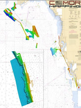
Previously the Florida Middle Grounds Version 3- the new West Florida CMOR Card features: major expansions of nearshore and deep drop spots, with privately collected data from Marco Island through St. Joseph Peninsula that has been mapped in high resolution for the first time, and exclusively on CMOR Mapping.
Coverage the West Florida CMOR Mapping Card includes:
-
St. Joseph Peninsula nearshore and deep drop coverage beyond Twin Ridges and Madison Swanson.
-
Big Bend exclusive data starting 25mi offshore Alligator Harbor with spots ranging from 5 fathoms to 11 fathoms.
-
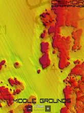
Expansion Northwest of the Middle Grounds ranging from 19 to 29 fathoms, in addition to the existing data of over 1000 square miles of coverage ranging from 75’ to 225’.
-
The Elbow covers over 50 square miles with depths ranging form 144 to 215’.
-
Expansion of Clearwater nearshore including shoreline data, 21’ bottom only 4 mi offshore, and new spots ranging from 6 fathoms to 10 fathoms in addition to over 20 square miles of data ranging from 38 to 55’.
-
The 40 break from Twin Ridges to Steam Boat Lumps.
-
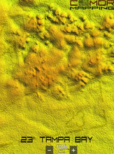
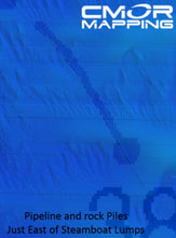
Tampa includes bay channel and targeted wreck, structure and pipeline data from Pendola Point to over 30 miles offshore with coverage in depths ranging from the shoreline to over 19 fathoms.
-
New Pass through Stumps Pass features shoreline data to 28’ and spots ranging from 27’ to 45’, and spots over 19 miles offshore in depths ranging from 65’ to 80’.
-
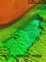
Boca Grand Pass includes 2.5 miles of Charlotte Harbor to over 4 miles offshore Boca Grande Pass with depths ranging from the shoreline to 69’ at the tarpon fishing hole.
-
Sanibel Island through Marco Island now features shoreline and privately collected data on some of the best fishing spots up to 35 miles offshore with depths ranging from the shoreline to over 50’ and spots such as the 7’ ledge to deep holes over 66’ deep.
Although the Middle Grounds is among the best fishing and diving areas in the Gulf of Mexico, it's still critical to know where you're going once you invest the time and fuel to make the trip. This CMOR Card features data that has been collected and processed in high resolution, for the first time in the world by The CMOR Mapping Team and has been made exclusive to CMOR Users.
CMOR Mapping high resolution bathymetry data arms you with more and better data than anybody else on the water.
NOAA Chart 11006 is included in the background.
All CMOR Cards with the exception of Furuno are provided on Micro SD cards with a standard SD adapter included.
Furuno customers: Please note that West Florida is not yet available on Furuno units- however Middle Grounds v3 is available for download. CMOR imagery for Furuno is not sold as a physical card. You will receive an unlock code to access the imagery on your device. We will need your NavNet system ID in order to generate the unlock code.
CMOR CARDS ARE COMPATIBLE WITH THE FOLLOWING DEVICES:
Furuno
FURUNO VERSION HAS NOT BEEN UPDATED TO WEST FLORIDA AND IS CURRENTLY AVAILABLE AS MIDDLE GROUNDS V3.
CMOR imagery is compatible with Furuno NavNet TZtouch2 and TZtouch3 multifunction displays (MFDs) with software version 6.23 or above.
CMOR imagery for Furuno is not sold as a physical card. Instead, it is preloaded on your MFD and accessed via an unlock code. After you purchase, you'll need to provide your system ID to CMOR vie email. You will then receive a unique code to unlock the imagery on your MFD.
-
NavNet TZtouch2
-
NavNet TZtouch3
-
TZT2 Blackbox
-
TZT3 Blackbox
-
TZTL12F
-
TZT14
-
TZTL15F


