**This Item Ships From Vendor Direct**
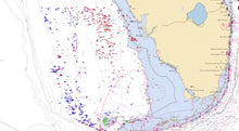
A StrikeLines EXCLUSIVE: We used side scan sonar to find over 45,000 KILLER natural bottom fishing spots nearshore and offshore for the Southwest Florida region.
Coverage areas include:
- Venice
- Boca Grande
- Captiva
- Fort Myers
- Sanibel
- Naples
- Marco Island
- Key West
Spots are marked from just off the beach to 130 miles offshore.
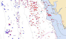
This chart shows the exact location of huge rock ledges. Boulders. Scattered rockpiles. Swiss cheese bottom. And hundreds of other premium fishing spots. You’ll have everything you need to catch grouper, triggerfish, tilefish, snapper, amberjack. You name it, this chart will get you hooked up.
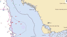
We located the best natural bottom structure, labeled it with descriptive waypoints and then outlined it with shaded boundary lines so that you will know exactly when your boat is over good bottom.
These spots have never been published anywhere before! We developed them through thousands of hours offshore scanning and processing professional side scan sonar data. If you fish offshore, this chart is, hands down, the best investment you can make. It will quickly pay for itself in gas savings alone.
More fish. Less stress. You’ll love it. Guaranteed.
This chart is fully compatible with Simrad, Lowrance and Mercury Vessel View.
The Garmin version of this charts is significantly stripped down due to limitations put in place by Garmin corporate. Garmin versions include 3,032 waypoints (versus 40,000+ for the Simrad/Lowrance version). And the Garmin version does not include the outlines/polygons that trace the reef structure.
Simrad, Lowrance, B&G, Mercury Vessel View, Raymarine, Garmin


